Coryat's
Crudities: Chris Rountree
Experiment
Chris's contribution was to take the form of a “guide book” – suggesting areas to visit and activities to carry out – albeit one written with no first hand knowledge of Nottingham. The book would direct users/readers to points chosen from a street map of the city to collect data in hand drawn "maps". The content and trajectories of these maps would be informed by a collage of ideas from the guide relating to the methodologies of post modern architect Robert Venturi and painter, Situationist theorist and architect Constant Niewenhuys. The results would contain elements of both analytical diagrams and expressive drawings.
This “data” was then, in turn, to be interpreted by the mappers in a series of “inhabitations” – performative interactions with the urban environment, reinterpreting the information taken from the guide at another degree of separation.
 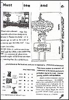
Guidebook cover (left); detail of contextual content
(right)
Findings
Two identical guidebooks were produced, specifying three particular streets for the mappers to map. The intention was for the mappers to each visit the three locations and to complete the first half of one book. They were then instructed to swap books in order to complete the second half based on the other's mapping. This unfortunately proved unfeasible given the structure of the conference and the limited time available. And so in the event only the "mapping" part was completed, perhaps giving Chris himself the opportunity to enact his own "inhabitations" at a later date, based on these results.
 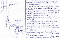
Details of the Parliament Street
mappings
|